Upcoming Event
 Free Newsletter

UPDATE: Florence inches across South Carolina
Staff Report //September 16, 2018//


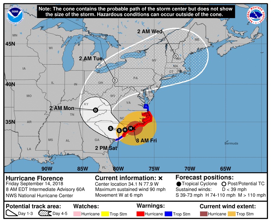
Updated at 8:30 a.m. Sunday
At 5 a.m. Sunday, Florence had been downgraded to a tropical depression and storm warnings and watches along the S.C. and N.C. coasts had been discontinued, but the National Hurricane Center continued to warn of the possibility of flooding in a "significant portion" of the Carolinas.
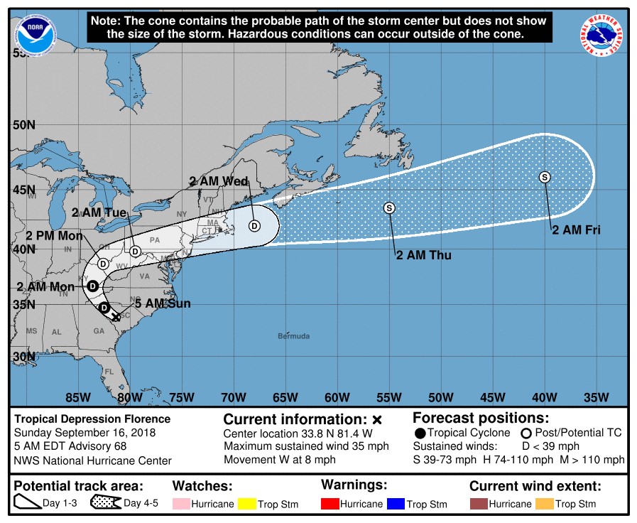 The system, with maximum sustained winds near 35 mph, was expected to move across western South Carolina and North Carolina today, then turn toward the Ohio Valley and the Northeast Monday and Tuesday.
S.C. Gov. Henry McMaster announced that evacuation orders for zones in Horry and Georgetown counties, the only remaining areas with such orders in place, would be lifted at 9 a.m. today. The governor also restored authority over school schedules to local authorities and said all state government offices will be open for normal business hours Monday.
The University of South Carolina, closed since Wednesday, announced it would resume normal operations Monday. Richland County offices also will be open for normal business hours tomorrow.
Updated at 3 p.m. Saturday
S.C. Gov. Henry McMaster said this afternoon that one fatality in the state has been attributed to Florence. Amber Dawn Lee, 61, died after her vehicle struck a downed tree in Union County last night, McMaster said during a briefing on the storm.
McMaster also said that all state offices and schools in counties except Horry and Georgetown are able to open Monday. Evacuation orders remain in effect for evaucation zones in those counties, McMaster said, and school closures there will be determined by local officials.
Richland District One tweeted that it would make a decision about whether schools would be open Monday by 3 p.m. tomorrow.
Nanette Edwards, executive director of the Office of Regulatory Staff, said the state's peak power outage occurred earlier today, with 171,899 outages reported. That number dropped to 118,833 as of 2:15 p.m., she said.
S.C. Secretary of Transportation Christy Hall said there were no major issues on state highways, but said transportation department officials were monitoring several bridges where flooding is expected, including S.C. Highway 9, S.C. Highway 917 and U.S. Highway 501. Hall said those roadways were expected to be overtopped by water by Monday or Tuesday, and the state was beginning to build flood control structures in those areas.
National Weather Service meteorologist John Quagliariello said Florence, a tropical storm with sustained maximum winds of 40 mph, was moving west across the state at 3 mph. A wind gust of 61 mph was recorded at Myrtle Beach International Airport, Quagliariello said.
 Quagliariello warned that up to 10 inches of rain were still possible in Rock Hill, Florence, Myrtle Beach and areas to the northeast.
"This is a hurricane event, followed by a flood event," McMaster said, saying that evacuation orders remained in effect in Horry and Georgetown counties because of the danger of flooding.
Six of the state's 80 open shelters were operating on generator power, officials said, including three in Marion Couny, two in Horry County and one in Dillon County. Officials said they were in constant contact with those shelters, and that no food issues had been reported. All shelters, with a capacity of 46,000, were 12% full as of this afternoon.
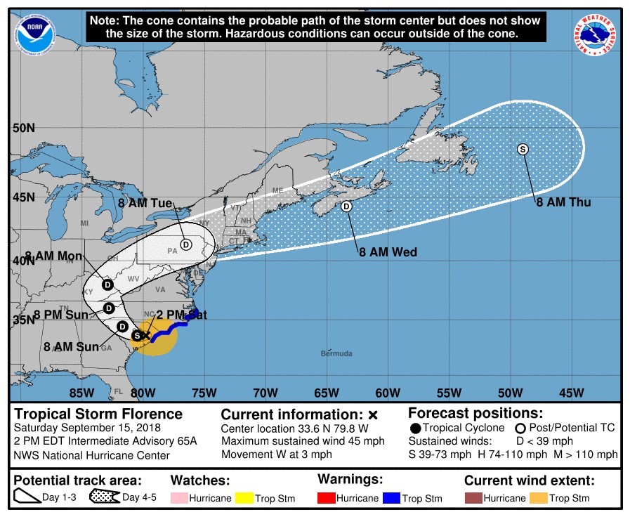
Updated at 8:30 a.m. Saturday
Florence crawled across South Carolina this morning as a tropical storm, moving westward at 2 mph with maximum sustained winds of 50 mph. The slow pace drenched areas in heavy rain and kept fears of flash flooding high.
An 8 a.m. advisory from the National Hurricane Center said the storm is expected to turn toward the west-northwest tomorrow, with a northward turn toward the Ohio Valley by Monday.
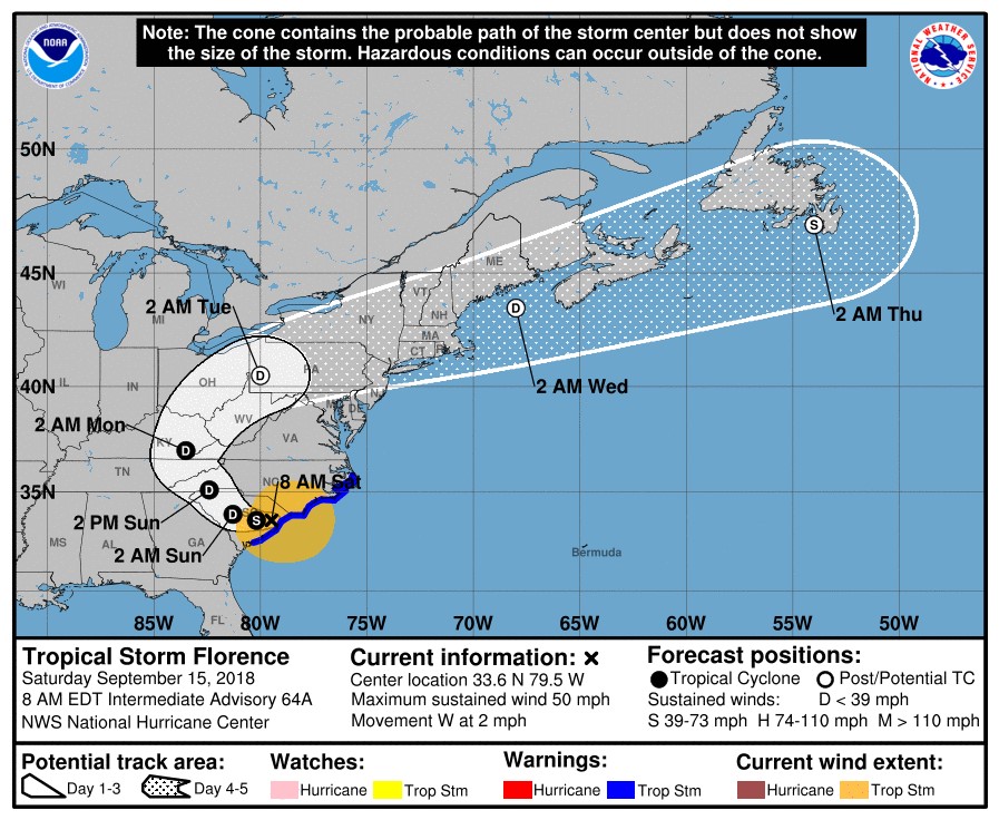 The center said Florence, which made landfall as a Category 1 hurricane near Wrightsville Beach, N.C. Friday morning, is expected to weaken to a tropical depression by tonight.
The Charlotte Observer cited Carteret County Emergency Services as saying that seven people in North Carolina died in the storm. That included a mother and a baby who died when a tree fell on their Wilmington home.
S.C. Electric & Gas said that nearly 3,000 workers, including more than 500 from out of state, stood ready to begin restoring power when it was safe to do so.
The restoration process includes assessing and repairing damage to large transmission towers, power lines and substations; clearing obstructions and repairing primary distribution poles and power lines; and inspecting and repairing secondary service drops in residential neighborhoods.
"It’s difficult to predict the number or duration of outages Hurricane Florence will create, but we will work safely, efficiently, and around the clock to restore power to all SCE&G customers as soon as possible," Bill Turner, SCE&G vice president of electric operations, said in a news release. "As we restore our transmission and distribution lines and substations, we are also working to restore power to public health and safety facilities."
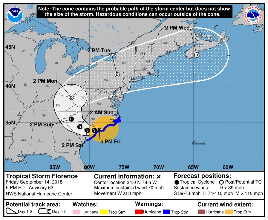
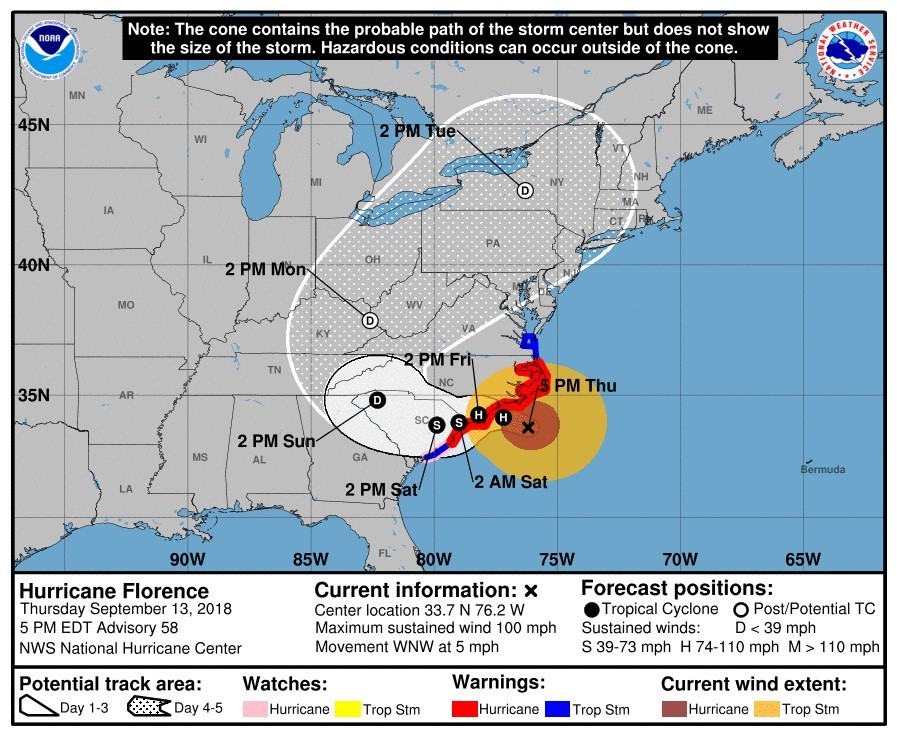
Updated at 7 p.m. Friday
The 5 p.m. advisory from the National Hurricane Center had Florence located 25 miles northeast of Myrtle Beach with maximum sustained winds of 70 mph. A hurricane warning was replaced with a tropical storm warning from South Santee River, S.C., to Cape Hatteras, N.C.
Updated at 3 p.m. Friday
S.C. Gov. Henry McMaster urged patience as the state braces for a long deluge of rain from Hurricane Florence, moving slowly toward the Midlands as a Cateorgy 1 storm.
"This hurricane is going to be with us for about two days," McMaster said during a briefing this afternoon. "We're going to have to have patience. We're going to have to have patience for a long time."
Florence made landfall near Wrightsville Beach, N.C., at 7:15 a.m. A 2 p.m. advisory from the National Hurricane Center said the storm was about 35 miles east northeast of Myrtle Beach, S.C., with maximum sustained winds of 75 mph. A hurricane warning stretched from South Santee River, S.C., to Bogue Inlet, N.C.
National Weather Service meteorologist John Quagliariello said a wind gust of 105 mph was recorded at the Wilmington airport this morning, the second-highest on record there. In S.C., the highest gust was 63 mph, recorded north of Conway, he said.
Quagliariello reiterated warnings about heavy rainfall and possible flooding associated with the storm, which he said was approximately the size of the state of South Carolina and inching along at around 5 mph.
The storm is expected move across southeastern parts of the state tonight and tomorrow, the NHS advisory said.
Officials expressed particular concern about flooding in the Pee Dee River Basin as water flows down from North Carolina and reminded residents to be patient in the event of power outages. As of 2 p.m. today, nearly 80,000 S.C. residents were without power, officials said, with more than 52,000 of those in Horry County.
The Department of Health and Environmental Control said it had assessed 262 dams in the projected path of the storm, and that it was monitoring around 30 of those.
South Carolina had 70 shelters open, 13 of which were for those with special medical needs. As of Friday afternoon, the shelters were at 14% of their capacity of almost 45,000 with more than 6,300 people in shelters.
Richland County will open an emergency shelter for pets at 3216 Broad River Road today at 5 p.m. The shelter is for dogs and cats only, the county said. Dogs must be on a lease and cats must be in a carrier, and only pets with up-to-date rabies vaccinations will be accepted. Pet owners must provide food, water and other daily care.
S.C. Secretary of Transportation Christy Hall said 441,000 people had evacuated in advance of the storm. The governor's office said 2,200 people were evacuated from 114 health care facilities along the coast.
The governor's office also said more than 660 state troopers, 450 state law enforcement officers and 3,249 National Guard personnel were on duty to help with recovery efforts.
McMaster also sounded a warning to looters, saying law enforcement would "show no mercy and spare no quarter."
"This is going to be a very trying period (but) I'm certain it's something we're equal to," McMaster said.
Updated at 2 p.m. Friday
The 11 a.m. advisory from the National Hurricane Center dropped the hurricane warning from Duck, N.C. south to Bogue Inlet to a tropical storm warning. A hurricane warning remained in effect from Bogue Inlet to south Santee River, S.C.
 Hurricane Florence was a Category 1 storm with maximum sustained winds of 80 mph as she slowly moved toward South Carolina. The hurricane center continued to warn of dangerous storm surge and flooding.
Two shelters were open in Richland County, with six more scheduled to open at 5 p.m. Ridge View High School at 4801 Hard Scrabble Road and Francis Burns United Methodist at 5616 Farrow Road were open. Scheduled to open at 5 p.m. were: Shandon Baptist at 5250 Forest Drive; Temple of Faith at 2850 Congaree Road in Gadsden; Trinity Church at 1501 Hallbrook Drive; Washington Street United Methodist at 1401 Washington St.; Grace United Methodist at 410 Harbison Blvd.; Shandon United Methodist Church at 3407 Devine St.
Only Grace United Methodist and Shandon United Methodist accept pets.
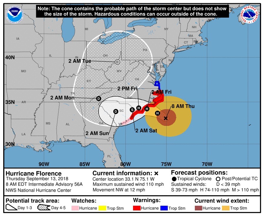
Updated at 8 :30 a.m. Friday
Hurricane Florence made landfall near Wrightsville Beach, N.C., this morning as a Category 1 hurricane, packing sustained maximum winds of 90 mph and bringing heavy rainfall.
 The National Hurricane Center said a large area from southeastern coastal N.C. into far northeastern S.C. could receive up to 20 to 25 inches a rain, a slight decrease from Thursday’s prediction of 20 to 30 inches. The remainder of North and South Carolina could receive from 5 to 10 inches, according to the center’s 8 a.m. advisory, with isolated areas receiving up to 15 inches.
The center continued to warn of the possibility of life-threatening flash flooding.
Updated at 7:30 p.m. Thursday
As of 7 p.m., Hurricane Florence was about 100 miles east southeast of Wilmington, N.C. and 155 miles east of Myrtle Beach, S.C. The slow-moving Category 2 storm was moving west-northwest at near 5 mph, the National Hurricane Center said, with maximum sustained winds of 105 mph.
 The center continued to warn of heavy, prolonged rain and the possibility of flooding. A swath stretching from southeastern coastal N.C. to far northeastern S.C. could see 20 to 30 inches of rain, producing catastrophic flash flooding and substantial river flooding, the center’s 7 p.m. advisory said.
The remainder of S.C. and N.C. and parts of southwest Virginia could receive 6 to 12 inches of rain.
The NHC said tropical storm conditions were already moving ashore within the hurricane warning area, which reached from South Santee River, S.C., to Duck, N.C.
Updated at 10:30 a.m. Thursday
Hurricane Florence approached the coast of the Carolinas this morning as a Category 2 hurricane with maximum sustained winds of 110 mph. At 8 a.m., the storm was around 170 miles east southeast of Wilmington, N.C. and 220 miles east of Myrtle Beach, S.C., the National Hurricane Center said.
A hurricane warning remained in effect from South Santee River, S.C., to Duck, N.C. Hurricane conditions are expected somewhere within the warning area within the next 12 to 24 areas.
 The center said the storm is expected to turn to the west-northwest tonight and Friday, with a slow west-southwest motion forecast Friday night and Saturday. The center of the storm will approach the S.C. and N.C. coasts later today and move near or over the warning area tonight and tomorrow. A slow motion over eastern South Carolina is forecast tomorrow night through Saturday.
Richland County announced Thursday that its 911 system had the capability to receive texts, but in a later email urged residents to call 911 instead of texting.
“While we are excited about this new technology, we feel that it is not in the best interest of public safety to launch this new feature during a critical weather event,” the county said.
Updated at 3:30 p.m. Wednesday
Gov. Henry McMaster urged S.C. residents in evacuation zones to heed warnings to leave as Hurricane Florence turned back toward the S.C. coast.
Officials said during an afternoon news conference that more than 300,000 people had already fled the coast in advance of the storm, with 18,000 seeking refuge in the state’s 35 evacuation shelters. The shelters have the capacity to hold 35,000 people.
A 2 p.m. advisory from the National Hurricane Center said Florence’s peak winds had decreased slightly but the size of the storm’s wind field had increased. The storm had sustained maximum winds of 125 mph, dropping it to a Category 3, and was located about 435 miles southeast of Wilmington, N.C.
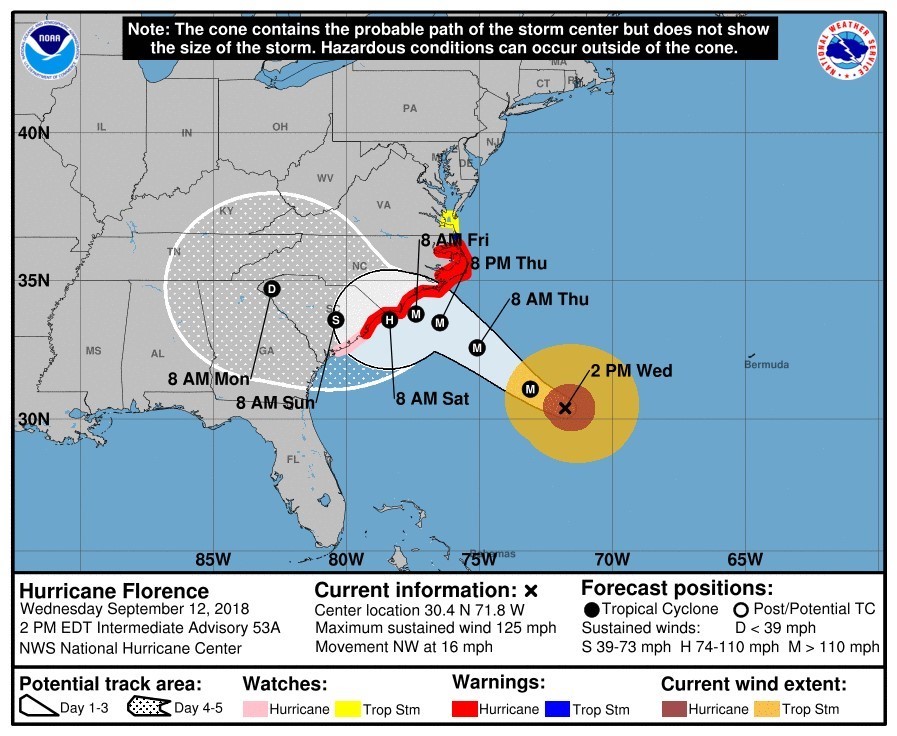 The advisory said wind strength may fluctuate through Thursday morning. The storm is expected to near the East Coast late Thursday.
“If you’re in an evacuation zone, you need to leave now,” McMaster said, warning of heavy rain and flooding in low-lying areas that he said could cause damage reminiscent of the historic flooding seen in the state in October 2015. “It may be worse than 2015.”
Leroy Smith, director of the S.C. Department of Public Safety, said lane reversals on major thoroughfares will end tomorrow. Reversals on Interstate 26 will stop at 6 p.m., while reversals on Highway 501 in Horry County will end at noon.
S.C. Adjutant General Robert Livingston said federal ships are positioned off the coast, ready to assist in hurricane recovery efforts.
The University of South Carolina, which has canceled classes through Saturday, also canceled its home football game against Marshall scheduled for Saturday at 7:30 p.m. The USC athletic department said the school would look to schedule another game later this season.
Updated at 9:57 a.m. Wednesday:
Hurricane Florence’s latest track turned the massive Category 4 storm back toward the S.C. coast this morning as more than a million people fled the Carolina coasts.
The storm turned slightly southwest, with its eye expected to pass between Bermuda and the Bahamas today. Tropical storm-force winds are expected to reach the S.C. and N.C. coasts by Thursday night, according to the National Hurricane Center’s 8 a.m. forecast.
The center issued a hurricane warning stretching from South Santee River, S.C., to Duck, N.C. A tropical storm warning was in effect from Duck, N.C., to the North Carolina/Virginia border.
The latest NHC advisory warned of life-threatening storm surges along portions of the S.C. and N.C. coasts, as well as “catastrophic” flash flooding in portions of the Carolinas and Mid-Atlantic states. The storm is expected to slow down as it moves inland, dumping huge amounts of rain.
The Associated Press reported scarcities of gas and water in portions of North Carolina. In Columbia, a Walmart had been picked clean of bread on Tuesday afternoon.
The University of South Carolina canceled classes through Saturday and said its Columbia campus will remain closed until further notice. Housing and food services and the student health center will continue to operate.
Federal Emergency Management Agency spokesman Jeff Byard told CNN that today is “the last good day to evacuate.”
Updated at 11:53 a.m. Tuesday:
S.C. Gov. Henry McMaster has lifted a mandatory evacuation order for zones in Beaufort, Colleton and Jasper counties as Hurricane Florence continues to track north.
As of 11 a.m. today, Florence remained a Category 4 storm with sustained maximum winds of 130 mph, according to the National Hurricane Center. It turned northwest, with forecasts now predicting landfall on Thursday between northern South Carolina and North Carolina’s Outer Banks.
McMaster also ordered schools and state government offices in Aiken, Allendale, Bamberg, Beaufort, Barnwell, Colleton and Jasper counties to open Wednesday.
An evacuation order remains in effect for all zones in Horry, Georgetown, Charleston, Berkeley and Dorchester counties and for Edisto Beach.
S.C. residents can find evacuation zones and other information at the S.C. Emergency Management Division’s website.
On Monday, warning that Florence packs “more wind than Hugo and more water than Matthew,” McMaster ordered mandatory evacuations for all zones in eight coastal counties and said state government offices and schools would close in 26 counties.
McMaster said Monday that more than 1 million people were expected to flee S.C.’s coast, beginning today.
Planned four-lane reversals on Interstate 26, starting at the interchange of I-26 and I-526 and continuing until the I-26 crossover with I-77 in Lexington County, began earlier than the announced time of noon today because of swift work by the state transportation department, the governor’s office said. Other planned lane reversals began today at noon.
In Horry County, two four-lane reversals began on U.S. 501 from S.C. 22 to S.C. 576 near Marion County and on S.C. 544 to U.S. 378.
McMaster had ordered schools and state offices closed in the above-mentioned counties as well as in the following: Berkeley, Calhoun, Charleston, Clarendon, Darlington, Dillon, Dorchester, Florence, Georgetown, Horry, Lexington, Lee, Marion, Marlboro, Orangeburg, Richland, Sumter and Williamsburg.
Richland County said in a news release that its offices were open for regular business hours today as officials continued to monitor the storm.
S.C. EMD director Kim Stenson said evacuation shelters would open today. Richland County will open Ridgeview High School on Hard Scrabble road to serve as a shelter at 4 p.m. today. The facility will not accept pets, but the county said it is making plans to accommade evacuees with domestic animals.
“(Offices and schools) will remain closed until further notice,” McMaster said. “The shelters will remain open until we don’t need them anymore.”
The University of South Carolina and Benedict College closed at 11 a.m. today. USC said it will be closed with classes canceled Wednesday, while Benedict is closed until further notice.
This weekend, McMaster declared a state of emergency (.pdf) and asked for a federal emergency declaration (.pdf) in anticipation of possible effects of the storm, upgraded to a Category 4 on Monday.
“This storm is too powerful and its path is too uncertain to take any chances,” McMaster said in making the declaration. “We are mobilizing the state’s resources to make sure we are prepared, and the people of South Carolina must not hesitate to prepare for the possibility of a hurricane impacting our coast.”
A news release from McMaster’s office said the state has 2,702 national and state guard and law enforcement personnel on standby and ready for deployment.
Earlier, the S.C. Emergency Management Division ordered 125 buses staged in Orangeburg to deploy to affected areas if needed and provided supplies such as sandbags and generators to counties as requested. The division said it has also contacted state emergency management agencies nationwide in case South Carolina needs to request resources and has deployed regional managers to assist coastal county agencies.
Richland County is operating at OpCon Level 3, which indicates an emergency situation is likely or imminent, with partial activation of its Emergency Operation Center.
Residents with general, storm-related questions may call the EOC at 803-576-3439.
-